
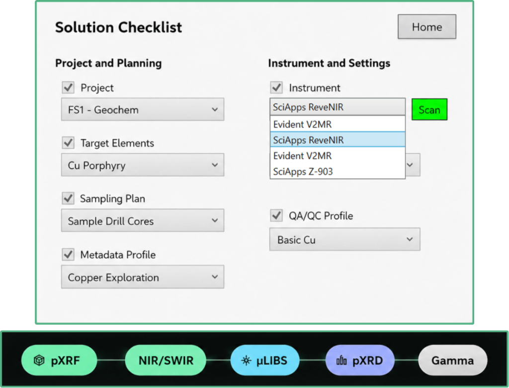
Unified Multi-Sensor Workflow
Organize results from supported pXRF, pNIR/pSWIR, pLIBS, pXRD, and portable gamma-ray technologies within a shared project, location, and sample structure. Each measurement remains linked to its instrument, method, acquisition settings, units, and method-specific outputs—making multi-sensor results easier to compare while preserving the distinctions between technologies.
- SUPPORTED INSTRUMENT CONNECTIONS
- CONSISTENT PROJECT AND SAMPLE STRUCTURE
- METHOD-SPECIFIC DATA PRESERVED
- CONFIGURABLE INSTRUMENT PROFILES
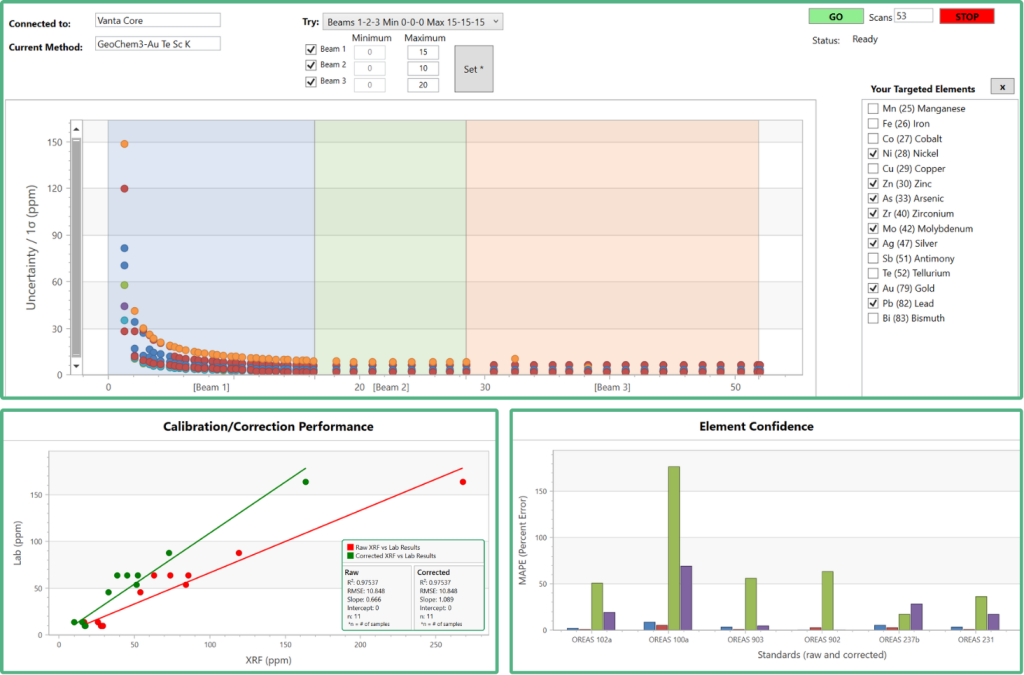
Embedded QA/QC
Build project-defined quality controls directly into acquisition. Configure standards, blanks, duplicates, calibration and drift checks, control frequencies, acceptance criteria, and element-specific thresholds. Automated prompts and rule-based evaluation help teams identify controls that are due, failures, drift, and results requiring review while corrective action is still possible.
- CONFIGURABLE QA/QC PROFILES
- STANDARDS, BLANKS AND DUPLICATE TRACKING
- CALIBRATION AND DRIFT MONITORING
- TRACEABLE PASS/FAIL AND REVIEW STATUS
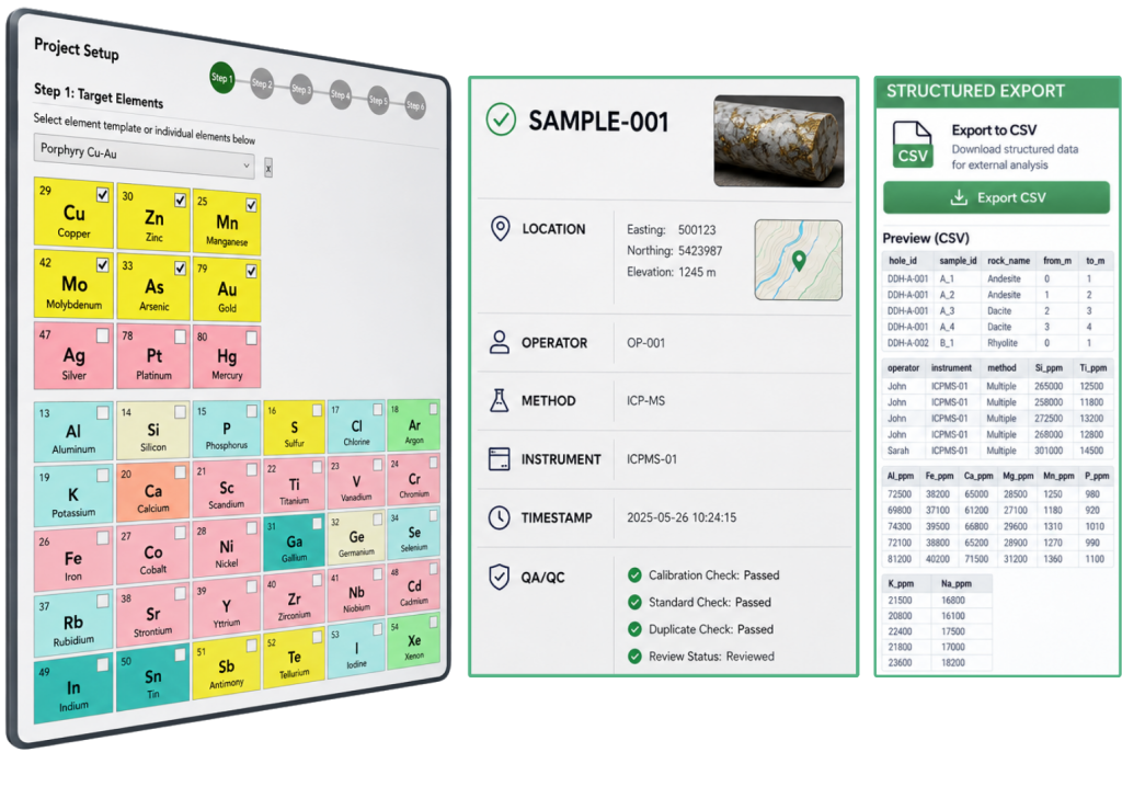
Metadata Standardization
Use project templates, sampling plans, metadata profiles, required fields, controlled inputs, and standardized units to capture consistent context at the source. Preserve sample identity, location or interval, operator, timestamp, preparation, method, instrument settings, calibration, and QA/QC relationships throughout review and export.
- PROJECT AND SAMPLING PLAN SETUP
- CONFIGURABLE METADATA PROFILES
- REQUIRED AND CONTROLLED INPUTS
- TRACEABLE EXPORT AND AUDIT HISTORY
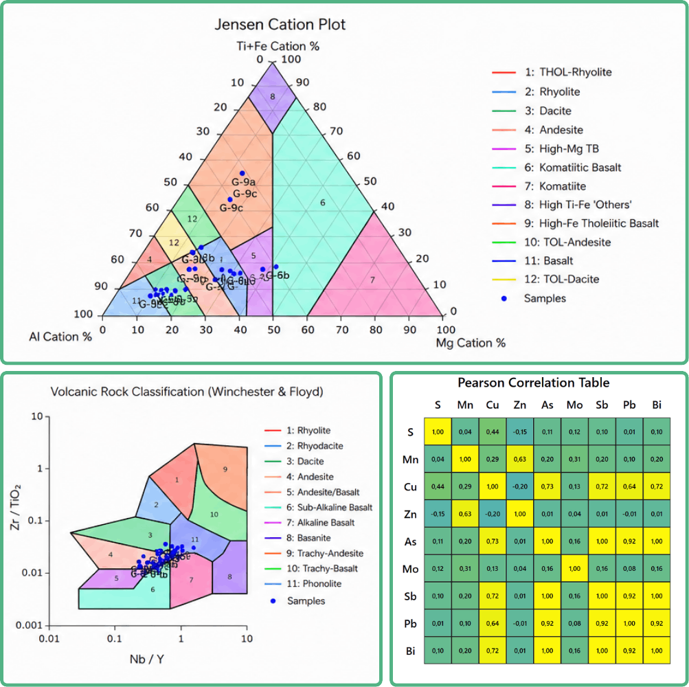
Real-Time Analytics & Visualization
Review results as they are acquired using project dashboards, scatter plots, ternary diagrams, elemental ratios, correlation tables, strip logs, geological classification diagrams, and QA/QC reports. Compare supported datasets, identify patterns, and prioritize follow-up while field activities are still underway.
- LIVE PROJECT DASHBOARDS
- GEOLOGY-DRIVEN PLOTS AND CLASSIFICATIONS
- RATIO, SPELLING, STRIP LOGS
- BUILT-IN AND CONFIGURABLE REPORTING
One connected workflow, from project setup to interpretation.
Configure the Project
Define target elements, sampling plans, metadata requirements, instrument settings, calibration profiles, and QA/QC rules in one structured setup.

Structure Sample Context
Create or import sample records with consistent identifiers, locations, intervals, preparation details, and geological observations.

Acquire and Validate
Collect measurements from supported instruments while scheduled standards, blanks, duplicates, and calibration checks help identify issues as they occur.
Validate QA/QC
Schedule control measurements, apply predefined acceptance criteria, review warnings and failures, and preserve the relationship between controls and the samples they govern.

Analyze During Fieldwork
Use dashboards, ratios, correlations, strip logs, geological diagrams, and classification tools to identify trends and guide follow-up.

Export and Synchronize
Export traceable datasets and reports, or synchronize approved results with connected cloud, database, modelling, and interpretation environments.
Integrate and Advance Interpretation
Use structured exports, synchronization tools, and supported or configurable API connectors to move organized, traceable field data into geological databases, modelling platforms, and professional interpretation workflows—while preserving sample identity, metadata, analytical methods, and QA/QC relationships.
Built Around the Complete Field-Data Lifecycle.
Create projects, users, target-element templates, sampling plans, instrument profiles, metadata profiles, calibration profiles, and QA/QC plans.
Connect supported instruments, apply method-specific settings, and collect measurements within a consistent project and sample structure.
Bring supported external or laboratory results into the project while preserving source, method, units, and provenance.
Track standards, blanks, calibration checks, repeat measurements, field duplicates, laboratory duplicates, and custom control materials.
Configure control frequencies, warning and error thresholds, drift criteria, and review status according to project requirements.
Use templates, required fields, controlled inputs, standardized units, and consistent sample identifiers.
Retain the relationship between results, samples, instruments, methods, users, calibrations, corrections, and QA/QC outcomes.
Use dashboards, scatter plots, ternary diagrams, ratios, strip logs, Jensen cation plots, and geological classification diagrams.
Produce structured reports and export datasets for review, documentation, and downstream use.
Operate the Windows field application with a local database when Internet access is unavailable.
Synchronize data with the browser-based cloud environment when connectivity is available.
Use available API/SDK connections or request custom instrument and downstream-system modules.
The official product description currently lists Windows desktop and browser-based cloud operation, offline capability, CSV/PDF outputs, API/SDK support, and automated reporting.
One Project Structure Across Multiple Analytical Methods.
pXRF
Rapid, multi-element geochemical analysis.
pNIR/pSWIR
Mineral identification and alteration characterization.
pLIBS
Complementary elemental analysis, including selected light elements.
pGAMMA
Radiometric measurements for geological and lithological context.
pXRD
Crystalline phase identification and mineralogical analysis.
Fieldscan ONE™ Integration & Compatibility FAQs
Fieldscan ONE™ supports a wide range of instruments from Evident, SciAps, and Spectral Evolution. Contact us for compatibility details.
Depending on the instrument and its specifications, Fieldscan ONE™ communicates using either USB or WiFi connections.
Yes. FieldScan ONE™ can synchronize project results and sampling plans with compatible cloud and third-party platforms through structured exports, connectors, or APIs.
Where the target system provides a documented API or supported import structure, a connector can be evaluated and configured around the required workflow.
Yes. Field acquisition and local review work offline; cloud synchronization, APIs, and connected services require Internet access.
No. Fieldscan ONE helps you get more value from your laboratory data.
It integrates lab-tested site standards into pXRF workflows, uses paired laboratory and pXRF results to create correction profiles, and incorporates site-standard testing into ongoing QA/QC activities.
This improves confidence in field measurements and supports faster, better-informed decisions.
Ready to put it in the field?
Request a demonstration tailored to your instruments, QA/QC requirements, metadata structure, analytical objectives, and field operating environment.
